n3gb-rs
Rust implementation of a hex-based spatial indexing system for British National Grid.
This work is inspired by GDS NUAR n3gb and h3o.
Work in progress, won't be perfect.
Core Structs
HexCell
A single hexagonal cell with a unique ID, center point, and zoom level.
Create one:
use n3gb_rs::HexCell;
use geo_types::Point;

// From BNG coordinates
let point = Point::new(383640.0, 398260.0);
let cell = HexCell::from_bng(&point, 12)?;

// From an existing ID
let cell = HexCell::from_hex_id("AAF3kQBBMZQM")?;
What you can do:
cell.id              // Unique Base64 identifier
cell.easting()       // Center X coordinate
cell.northing()      // Center Y coordinate
cell.to_polygon()    // Get the hex as a Polygon geometry
HexGrid
A collection of HexCells covering a bounding box/polygon boundary
Create one:
use n3gb_rs::HexGrid;

// Using builder
let grid = HexGrid::builder()
    .zoom_level(12)
    .bng_extent(&(300000.0, 300000.0), &(350000.0, 350000.0))
    .build()?;

// Direct construction
let grid = HexGrid::from_bng_extent(&(300000.0, 300000.0), &(350000.0, 350000.0), 12)?;
What you can do:
use geo_types::point;

// Look up a cell by point
let pt = point! { x: 325000.0, y: 325000.0 };
if let Some(cell) = grid.get_cell_at(&pt) {
    println!("{}", cell.id);
}

// Iterate over all cells
for cell in grid.cells() {
    println!("{}", cell.id);
}

// Export to GeoParquet
grid.to_geoparquet("output.parquet")?;

// Export to Arrow RecordBatch
let batch = grid.to_record_batch()?;
WGS84 to BNG conversion
Any function that accepts WGS84 coordinates requires a ConversionMethod argument. Two backends are available:
| Method | Accuracy | System requirement |
|---|---|---|
ConversionMethod::Ostn15 | ~1mm always | None (data embedded at compile time) |
ConversionMethod::Proj | ~1mm with grid files, ~5m without | libproj system library |
Stay with Ostn15 (default) unless you have a specific reason to use PROJ.
When PROJ grid files (uk_os_OSTN15_NTv2_OSGBtoETRS.tif) are not installed, PROJ silently falls back to a Helmert transform with ~5m error — no warning is raised.
To check which pipeline PROJ is actually using at runtime:
PROJ_DEBUG=2 cargo run
Look for uk_os_OSTN15_NTv2_OSGBtoETRS.tif - succeeded (grid active) or OSGB 1936 to WGS 84 (6) (Helmert fallback). The check_proj example automates this check.
use n3gb_rs::{HexCell, ConversionMethod};

// Recommended
let cell = HexCell::from_wgs84(&(-2.248, 53.481), 12, ConversionMethod::Ostn15)?;

// Only if you know libproj + grid files are installed
let cell = HexCell::from_wgs84(&(-2.248, 53.481), 12, ConversionMethod::Proj)?;
Zoom levels
Each zoom level has 7x the area of the next finer level (aperture 7).
| Zoom | Radius (m) | Width (m) | Use case |
|---|---|---|---|
| 0 | 1,281,250 | 2,219,190 | All of GB |
| 5 | 9,850 | 17,060 | Regional |
| 10 | 75 | 130 | Neighbourhood |
| 12 | 10 | 18 | Street level |
| 15 | 0.58 | 1 | Sub-metre |
Cell widths follow the formula: width(zoom) = (sqrt(7))^(15 - zoom)
Modules
| Module | What it does |
|---|---|
cell | HexCell — single hexagon with ID, center, row/col |
grid | HexGrid — collection of cells covering an extent |
coord | Crs enum, ConversionMethod enum, WGS84 to BNG transformations (PROJ + OSTN15) |
geom | Hexagon polygon creation, WKT/GeoJSON parsing |
index | Hex ID encoding/decoding, point to row/col math |
dimensions | Hexagon dimension calculations |
io | Arrow, GeoParquet, and CSV I/O |
Examples
Simple hex grid over Manchester at zoom level 10
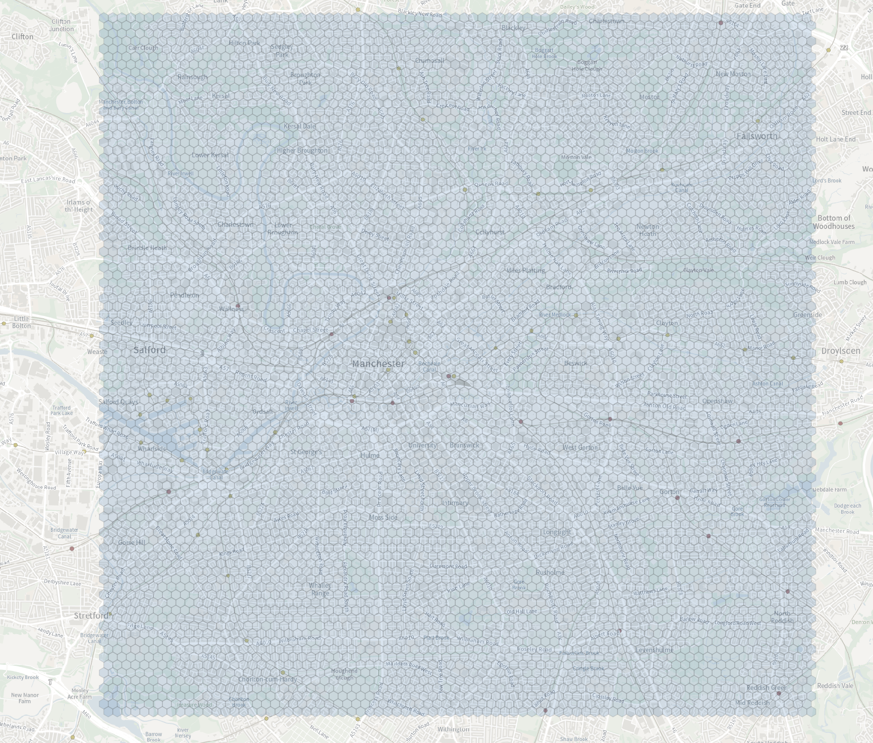
Base map © Crown Copyright and database rights Ordnance Survey.
UPRN density heatmap — count of Unique Property Reference Numbers per hex cell at zoom level 6
Working on fixing some of the bad geometries that appear.
Hunch is that it's the source data that is wrong for some of them.
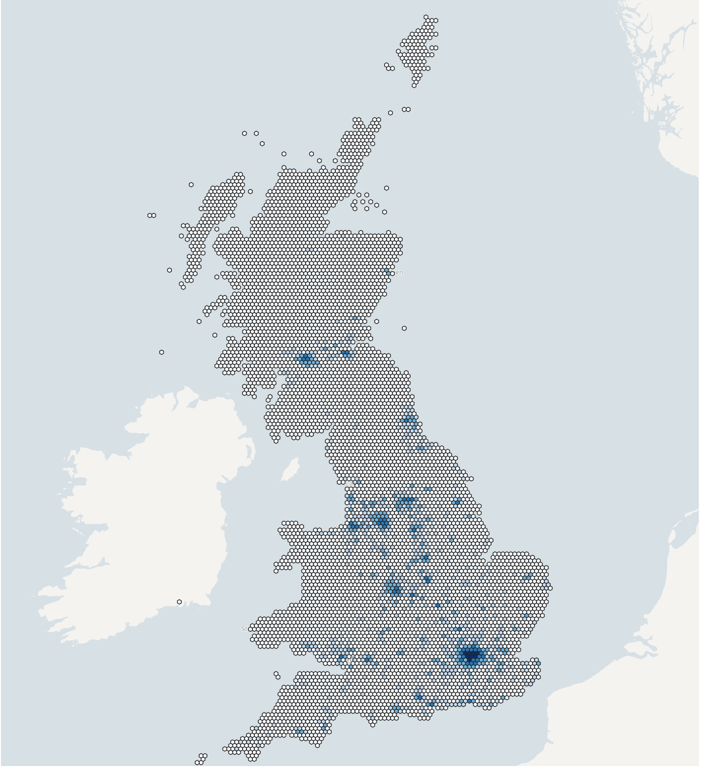
Base map © Crown Copyright and database rights Ordnance Survey. UPRN data licensed under the Open Government Licence v3.0, contains OS data © Crown Copyright and database rights.
Cadent open pipeline dataset — each pipe indexed to the hex cells its line passes through
Using line coverage (from_line_string_bng / from_line_string_wgs84) at zoom level 11, every pipe feature keeps its original attributes and gains a hex_ids list — one entry for a short pipe, several where a longer line crosses multiple cells.
| type | pressure | material | asset_id | hex_ids |
|---|---|---|---|---|
| Service Pipe | LP | PE | CDT1248335481 | [AQAAAAAfkU50AAAAAArOz-kLDg] |
| Service Pipe | LP | PE | CDT1248355939 | [AQAAAAAeWkV0AAAAAAodZPALuA, AQAAAAAeWqUoAAAAAAoeCrMLNg] |
| Main Pipe | LP | PE | CDT1248359381 | [AQAAAAAf9X7kAAAAAAsqwjYLrw] |
| Main Pipe | LP | PE | CDT1248363703 | [AQAAAAAi9_sIAAAAAAsSzP4LDw] |
Run over the full open dataset, every feature is tagged in a single pass — input columns straight through, plus the new hex_ids list:
=== Gas-pipe infrastructure -> hex ID lists ===
Input:  gas-pipe-infrastructure-gpi_open.parquet
Column: geo_shape (WKB (Multi)LineString, WGS84)
Zoom:   11
Output: gas-pipes-with-hexids-z11.parquet  (input + `hex_ids`)

Features:          2,268,971
Cell memberships:  5,559,918
Avg cells/feature: 2.45

Elapsed: 2.57s (882,893 features/sec)
Cadent gas pipeline data licensed under the Open Government Licence v3.0.